Part B Vukuzenzele how-to guide
In this Part B of the User Manual we provide insights into the ways ReBlok can add value in the project cycle. As mentioned in the first part, our role is mostly in Phase 1: Pre-Planning of the UISP project cycle. Considering that this project cycle is the best-documented process, we provide ten steps in which community participation in the planning and implementation stages can be supported.
In each step we provide a brief overview and important considerations. We then provide an indicative list of what is needed to complete the step and the recommended approach to complete the step. Finally, we provide other useful resources which have informed our work and have become the benchmarks for standards in many ways.
Step 1: Selecting a site
Description
Site selection in informal-settlement upgrading is the starting point of any project. The National Upgrading Support Programme (NUSP) has supported the compilation of ‘Rapid Assessment and Categorisation’ (RAC) of informal settlements in many municipalities across the country. This means that many local governments might already have conducted a prioritisation and selection process of sites. If this exists, the local government could have already selected priority settlements.
In this first step, we believe that this information should be verified if it is outdated. We discuss the approach to developing site selection and suitability criteria including the various overlaying legal, infrastructural, environmental, planning and social systems that impact on settlement upgrading.
Important considerations
When selecting settlements for upgrade, a political engagement strategy might be required. A settlement might also be part of a social movement which might have its own prioritisation logic. It is very important to do a thorough assessment of stakeholders to avoid political conflict and contestation. At the same time, the upgrading process cannot be captured by political interests, and the prioritisation should occur in a transparent and equitable manner.
The functionality of settlements within the town- or city-context is also important. Not all informal settlements have the same population groupings, and this will require sensitivity in selecting an appropriate project conceptualisation.
Did you know? The difference between core-zone and peripheral-zone informal settlements
One of the major findings in the research of Catherine Cross and her colleagues at the Human Sciences Research Council (HSRC) who conducted randomised surveys in Gauteng and Mpumalanga was that differences are drawn between ‘core zones’ and ‘peripheral zones’ in urban centres.
‘Core-zone shacks’ are likely to be composed of single households of mostly young men with a lower unemployment rate than shack settlements on the periphery. Settlement densities are likely very high and shacks have small floor space. Peripheral shacks, on the other hand, typically have larger household sizes with families and young children. (Cross 2010; Görgens and van Donk 2012)
What you would need
- List of settlements with boundaries.
- If available: Rapid Assessment and Categorisation (RAC) spreadsheets and technical documentation.
- GIS base layers covering property ownership, environmental management, flood lines, slope topographies, infrastructure capacity, zoning rights, and so forth.
- Preliminary stakeholder database.
- Any other inherent site selection logic, such as the Housing Sector Plan (HSP) in the Integrated Development Plan (IDP).
Recommended steps
- Confirm the status of the settlement: Confirm whether the municipality has an up-to-date RAC assessment, and where informal settlements are categorised according to 4 classes: A = full upgrade, B1 = interim basic services, B2 = emergency basic services, C = imminent relocation. Based on this categorisation, the municipality might have already prioritised settlement upgrading and allocated budgets.
- Set up an assessment framework: If a credible and transparent assessment framework does not exist, it is important to screen candidate informal settlements against a framework that includes, at a minimum, the various overlaying legal, infrastructural, environmental, planning and social systems. ReBlok has developed a site-assessment matrix that can be deployed in this phase.
- Collect baseline information: Collecting GIS data is an important supplement to the assessment framework. The Project Preparation Trust (2014) recommends that the GIS baselines should include, at a minimum, the settlement showing boundaries, slope analysis, constraints/undevelopable land, property ownership, and development suitability and potential.
- On-site verification: No amount of desktop research can replace the need to walk the boundaries of the informal settlement and preliminarily engage community leaders and structures. The upgrading will also most likely take place in situ. On-site verification could also be coupled with initial geo-technical evaluations such as critically endangered biodiversity for conservation and soil-condition analysis.
- Prioritisation for upgrading: Once a schedule of informal settlements with potential for upgrade has been compiled, the municipality or provincial government should prioritise funding through the preparation of business plans, budgets, tender processes and the appointment of service providers.
Other helpful resources:
- Project Preparation Trust (2014), Rapid Assessment and Categorisation (RAC) Guidelines: This document outlines in great detail the process that is required to conduct an RAC assessment.
ReBlok services
ReBlok has developed site-selection criteria in a matrix format to help steer the process of selecting settlements for upgrading based on our project-level experience.
Step 2: Pre-planning consultations
Description
Following site selection, the municipality prepares its business plans and applies for funding from provincial-government departments. The provincial government might also be the lead funder and project owner. ReBlok assumes that all procurement processes would have been completed and the project team would be appointed when pre-planning consultations commence.
During the pre-planning phase, a number of essential community-engagement processes commence, and it is also during this phase that ReBlok’s services are most relevant. A project plan developed in a participatory manner will most likely enjoy the support of the local beneficiary community. This local ownership could result in a much more impactful process, and investing upfront in relationship management could yield long-term benefits.
Important considerations
A number of tasks should be completed in the pre-planning stages of the project cycle. These tasks include community engagements, socio-economic surveying of households, training on housing rights, capacity building, assistance in relocation and building-material management.
To this end, 3% of the project budget has been ring-fenced to finance community engagements and related pre-planning activities. During this phase, the value proposition of ReBlok has relevance. An upfront investment in time, resources, and capacity building during the pre-planning phase will most likely result in an improved project cycle.
Over and above the GIS base layers required (see Step 1), analysis of baseline information should ideally also place the informal settlement within the context of the town or city; proximity to public transport, existing infrastructure and services (infrastructure and social), movement patterns (e.g. footpaths and desire lines) and economic centres. Community concerns will most likely touch on issues beyond settlement upgrading, and making strategic recommendations to the local government to improve spatial transformation is essential.
What you would need
- Contractual agreements after procurement processes were concluded.
- Establishment of a project steering committee.
- Initial stakeholder database.
- Development parameters as determined in Step 1 after analysing GIS base layers.
Recommended steps
-
Conclude all procurement processes: To access finance for the project, the lead applicant (local or provincial government) will compile business plans, terms of reference, tender documentation and adjudication; sign contracts with a service provider; and commence the project. ReBlok assumes that this project context would exist at the time when the pre-planning phase commences.
-
Host an inception meeting with the project steering committee (PSC): This process runs concurrently with Step 3: Stakeholder Analysis. Once there is clarity on the important stakeholders, the PSC will be assembled and roles and responsibilities will be assigned. It is important to orientate the PSC on collaborative planning and implementation, and ReBlok has extensive experience in building project-team capacity.
-
Finalise project plan: An output of the inception stage is an inception report, which will also finalise the project plan.
-
Determine basic parameters for development: Some of this work would be completed in Step 1: Site Selection. It is important to set the parameters for development before engaging communities. In other words, conducting desktop research of the various overlapping legal, ecological, zoning, social and economic systems will help the project team to go into the pre-planning phase with sound advice on the feasibility of certain proposals.
-
Conduct spatial analysis: It is recommended that the context of the settlement in the town or city’s regional economy is well understood. There are issues that might affect the settlement such as poor transport linkages which fall beyond the scope of the project but should be considered by other government agencies and/or departments.
Other helpful resources
- Department of Human Settlements. 2009. Housing Project Process Guide: This document provides a detailed project plan of the UISP upgrading process.
- NUSP. 2018. NUSP Resources Kit: This 10-part training course available for free online has some of the best materials for training teams embarking on settlement upgrading, and it is highly recommended that these resources be studied by the PSC.
ReBlok services
ReBlok has extensive experience in building institutional capacity on the upgrading process, and can support the establishment and mentoring of PSCs.
Step 3: Stakeholder analysis
Description
The process of upgrading an informal settlement necessitates a thorough stakeholder analysis. Many informal settlements were formed through land invasions, government relocations, and/or the overcrowding of existing backyard shacks and public housing stock. Social relations and networks emerge over time, and often have a political affiliation.
Street committees, crisis committees, saving groups, youth and culture groups, faith-based organisations, NGOs and a number of other voluntary groups might be present in the settlement. Natural leaders might also emerge due to past involvement in government projects. There might also be factions in communities where two groups do not share a common vision and could disrupt a process.
By being thorough in stakeholder analysis, the project team could work out a feasible strategy to engage a wide proportion of the community and receive support and commitment to collaboration. Failure to do so could result in disruption to the process.
Important considerations
The UN Habitat (2014) provides a very useful framework in which to conduct stakeholder analysis and prioritisation. It is recommended that at minimum the stakeholders be screened against some of the following leading questions:
- How important is the stakeholder for the success of the programme?
- What level of support does the stakeholder currently show?
- What is it we would like them to do for the programme?
- What are the stakeholder’s main interests?
- How could they oppose and block the upgrading project?
- How will we need to address the stakeholder to increase their support and likelihood of their contributing what is hoped?
An analytical framework or matrix can be set up which, at a minimum, engages the stakeholders’ importance, influence and level of support. Some of this work could be conducted in the process of the service provider preparing its due diligence and risk assessments before tendering for this work.
| Stakeholder (for example) | Importance (high–low) | Level of influence (high–low) | Current level of support (high–low) | What do you want from stakeholder? | Stakeholder main interest | How could stakeholder block progress? |
|---|---|---|---|---|---|---|
| Provincial Dept of Human Settlements | High | High | High | Funding commitment, policy reform, project management | Improved living conditions, upgrading targets | Not prioritising according to local govt needs |
| Local government planning department | High | High | Medium | Project owner and excellent communication | Successful project delivery | Incompetence and/or lack of capacity |
| Residents | High | Medium | High | Ownership, support, collaboration, peaceful negotiation | Improved living conditions | Direct protest action |
| NGOs | Medium | Low | High | Capacity building and partnerships | Service provision to target population group | N/A |
| Service provider | High | Medium | High | Efficient yet inclusive project management | Commercial viability and zero delays | Cease works order due to conflict; court cases |
What you would need
- Initial stakeholder database.
- Time schedule to meet groups and organisations.
- Conflict resolution and development-facilitation experts.
- Strong networking capacity.
- Stakeholder/customer-relationship-management (CRM) systems.
Recommended steps
-
Compile stakeholder-analysis matrix: Develop a contextually appropriate matrix against which to assess the stakeholders’ interests, influence and importance. Based on this assessment, certain risks and potential for partnerships can be explored.
-
Identify capacities and skills in the community: During the initial stakeholder analysis, try to capture the existing skills and capacities in the informal settlement. For example, in a settlement located in the city centre there might be a lot of skilled construction workers, who could be valuable in supporting the project roll-out. Identifying these skills will be helpful when recruiting local opportunities, such as the Expanded Public Works Programme (EPWP) or Community Work Programme (CWP).
-
Plan for a communication strategy: Based on the risks and potentials identified, compile a nuanced communication strategy to enhance the contributions of stakeholders, manage the risks of influential stakeholders posing a threat to block progress and contributing to improved community-government-service provider relationships. Engagement should be hands-on and on-the-ground. For example, enumeration is conducted by trained community members, providing an opportunity to capacitate community members to be able to answer any questions and promote the game as they go door-to-door.
-
Determine partnership and conflict-resolution processes: Working with development-facilitation and dispute-resolution experts will help the project team to deal with the thorny issues of mistrust, political contestation, and liaison with neighbouring property owners (depending on the location of the site). There should be team members who are fully conversant in the local language and are trained and familiar with the project cycle.
-
Compile a CRM system: It is important to maintain a stakeholder database during engagements. There are free alternatives to more expensive systems, such as InSightly.
Other helpful resources:
- UN Habitat. 2014. A practical guide to designing, planning, and executing city-wide slum upgrading programmes: This document provides a strategic approach to designing and implementing projects, and Chapter 2 focuses on the project-initiation component.
ReBlok services
We provide skilled development-facilitation services and have strong links with existing community networks, such as the Informal Settlement Network (ISN) and Federation of the Urban Poor (FEDUP).
Step 4: Data collection through enumeration
Description
A socio-economic survey of the selected informal settlement is a key deliverable in the pre-planning phases of the upgrading project. The enumeration process not only results in data collection at the household level, but also mobilises the members of the community towards developing an agenda for the upgrading project. For this reason, it is highly advisable to recruit enumerators from the community and not have external workers doing this work. Enumerations are a way of spreading the news of the upgrading project through existing networks.

Modifying a census-type questionnaire will be important to align data fields and still receive nuanced and contextual household-level data. The Project Steering Committee (PSC) should be a key stakeholder in the compilation of the stakeholder analysis, and at this stage community leaders can also draw on their experience of issues that might require deeper study. For example, there might be a specific issue of children not attending school and low capacity in Early Childhood Development (ECD) centres. Incorporation of additional questions should be motivated and the final questionnaire should be signed off by the PSC.
Important considerations
One of the main goals of the UISP is to create tenure security, and enumeration is also a process of building up towards flexible tenure options and/or the so-called ‘continuum of tenure’. This means that protection against evictions, a sense of local ownership and property investment are all tied up with granting tenure security. The continuum ranges from administrative recognition (e.g. certificate, overlay zoning rights, etc.) towards formalised tenure (e.g. freehold rights registered with the deeds office).
It is therefore important to design the enumeration questionnaire so that it also links to the shack number of the socio-economic database at household level. CORC, an NGO affiliated with Shack/Slum Dwellers International, has advanced participatory enumeration practices in South Africa where communities undergo a self-enumeration and verify information.
Did you know?
In preparation for a ‘mega upgrading project’ of 13 settlements along the N2 Corridor near the Airport Precinct, the Western Cape Department of Human Settlements appointed, through a competitive tender, the Community Organisation Resource Centre (CORC) to enumerate all these settlements. CORC spent nearly a year enumerating and analysing the data of 13 settlements with a total of 20 715 households and 48 794 residents. This work was completed in March 2017, and forms the baseline data for the pre-planning phase managed by Aurecon.
– WCG Department of Human Settlements, 2017
Information from enumeration contributes to building the community’s bespoke Vukuzenzele level. It enables ReBlok to refine the drone images and to confirm the location of existing spaza shops and crèches, which can be incorporated into the game.
What you would need
- Enumeration questionnaire and digital collection devices/
- GIS base layers with digitisation of shacks from aerial photography/
- Trainers and training materials/
- Secure databases, data storage and data analysis (noting sensitivities in terms of the Protection of Personal Information Act, 2013)/
Recommended steps
If development practitioners intend to initiate a re-blocking project then they would follow the steps for site selection as elucidated in earlier chapters in the milestone document.
-
Co-producing the questionnaire: A base enumeration template might be available from the client (i.e. relevant government department) or needs to be created. This is a participatory process and the PSC’s input is important for the data requirements. The final step is to sign off on the questionnaire and ensure a process for data management, confidentiality and analysis.
-
Training of enumerators: Recruitment of local enumerators/data collectors is essential. These data collectors should be trained in the digital devices, have generic answers on topics (e.g. data confidentiality, upgrading process, timelines, etc.), and receive supervision at the neighbourhood block level (e.g. 150–250 shacks in a block in large settlements).
-
Collection of socio-economic data: If the enumeration is for a large settlement, GPS and digital-data-collection devices will most likely create a more effective workstream than paper-based questionnaires. Data collection and back-up storage is important, and devices should be fully charged when daily work commences.
-
The physical numbering of shacks: The numbering of the shacks should be done as systematically as possible. The mapping of the shacks needs to be as accurate as possible. In order to do this people need to be trained in how to use a tape measure, and how to accurately measure and record measurements of all the walls of a shack.
-
GIS database merges and data verification: Linking the socio-economic data to shack numbers can result in spatial analysis. This also supports a digital record for future work relating to tenure security including issuing administrative recognition. Furthermore, it is recommended that the enumeration results be conveyed back to the community for final sign off and verification.
-
Refine the Vukuzenzele game level: The original game layer is built from drone images and can now be made more accurate: for example, by adjusting shack sizes to account for roof overhangs.
Other helpful resources
- UN Habitat, 2010. Count me in: Surveying for tenure security: In this useful manual, the UN Habitat outlines a number of case studies and best practices for approaching an enumeration survey in the contexts of informal settlements.
- Urban LandMark. 2007–2013. Publications on tenure security: In this series of publications on the continuum of tenure in informal-settlement upgrading contexts, Urban LandMark conducted some of the most seminal research on the topic. One resource, in particular, is very relevant to enumeration studies: Incrementally securing tenure: an approach for informal-settlement upgrading in South Africa (2010).
ReBlok services
We have conducted numerous enumeration exercises and work in partnership with other organisations on larger enumeration projects.
Step 5: Participatory mapping and initial concept planning
Description
ReBlok is committed to participatory planning and continues to develop new products and processes to facilitate the incremental upgrading of informal settlements. One of the most useful tools or tactics that we have discovered is that of participatory mapping. This exercise precedes the gameplay of Vukuzenzele, the game-based version of participation.
Participatory mapping allows the project team to work with community leaders and walk the settlement without any preconceived idea or project concept. Allowing community leaders to talk about the lived experience can be facilitated proactively through a mapping exercise. We also recommend that drone mapping forms part of this stage.
Important considerations
The project team needs to be prepared to take key members from the community leadership through a training process to help understand, in simple terms, the process of upgrading an informal settlement. This step overlaps with the next steps, in which we try to convey the key design principles that will inform the concept planning.
It is important to receive the community’s input in its raw format. Ask questions such as: What happens on a Saturday? Where have crimes been reported? Are there spaces where women and children particularly feel unsafe? What are the main informal footpaths that people use to move through the settlement?
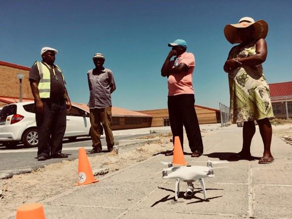
Flying a drone over the settlement in a pre-determined flight path can also happen at this point. ReBlok’s experience has been that drones should be deployed with a view to also using photogrammetry software and building a 3D model. On this model, the CAD version of the settlement can also be built, and used for more detailed planning.
Policy focus
Flying a drone is not as simple as launching it and completing the flight path. According to the Civil Aviation Authority a ‘remotely piloted aircraft’ (RPAS) means an unmanned aircraft that is piloted from a remote pilot station, excluding model aircraft and toy aircraft. Flying an RPAS requires a licence from the CAA. Furthermore, drones might be prohibited in so-called ‘controlled airspace’, which is designated as a 10km radius from an aerodrome.
There are restrictions on flying an RPAS in any of the below circumstances:
- near manned aircraft
- 10km or closer to an aerodrome (airport, helipad, airfield)
- weighing more than 7kg
- in controlled airspace
- in restricted airspace
- in prohibited airspace
- nearer than 50m to any person or group of persons (like sports fields, road races, schools, social events, etc.)
- nearer than 50m to any property without permission from the property owner.
In ReBlok’s experience of flying drones in controlled airspace, the following process needs to be followed, and ReBlok and its service providers are fully compliant.
- Ensure the drone pilot has an RPAS licence.
- Notify community leaders of the intended flyover and distribute information leaflets to all households.
- Set up a meeting with the local Air Traffic Control and Management (ATNS) office at the airport.
- Discuss the project and sign a Memorandum of Understanding (MoU) for the use of flexible airspace with annexures including the flight paths, times and durations, radio frequency with tower navigation, and safety and emergency response plan (e.g. having a fire extinguisher on site, retrieval plan in case of lost remote access to drone, etc.).
- Execute the drone operation while being in radio contact with the tower at all times.
- Close out the operation with radio communications.
What you would need
- The necessary licences and clearance to operate a drone and use of photogrammetry software.
- Paper-based maps at a large scale (e.g. A0 size) to facilitate community-based planning/mapping.
- Initial concept planning based on community inputs.
Recommended steps
-
Set up project planning teams: Ideally volunteers would have emerged through the PSC processes and can be trained at the neighbourhood block level. This core team will be trained and asked to undertake mapping.
-
Print physical paper-based maps: Break up the settlement into neighbourhood blocks and print detailed maps for each of these blocks. In a collaborative workshop on an ongoing process, receive the community’s inputs through community-based mapping. Orientate the user by asking them to mark their dwelling on the map.
-
Community mapping: After the community members have been orientated, take on thematic issues such as land uses, walking paths, infrastructure service points, and other important localised features such as occurrences of flooding, landslides, fires and so forth.
-
Fly a drone flight path: While community-based mapping takes place it could be the ideal time to fly over a drone with a set flight path to cover the extent of the settlement’s boundaries. This large-format file is essential in preparing the Vukuzenzele game base file.
-
First draft of the concept plan: After collecting the community’s inputs, track down all the inputs in a draft concept plan indicating, at the very least, the urban structure of paths and open spaces, points of interest, infrastructure, crime hotspots and so forth.
Other helpful resources
- SAPI and SACN. 2015. Know your block: Work to make a great place: These guidelines provide a useful process for approaching community-based planning exercises.
ReBlok services
ReBlok and its partner iKhayalami are experienced community-development facilitators and could add value working alongside urban designers, planners, architects and engineers.
ReBlok can manage the drone flyover with its partners or the client’s chosen supplier.
Step 6: Determining design principles and concept plan
Description
Design principles should guide the compilation of the concept plan and steer the options for infrastructure over time. Ideally the design options will not result in widespread displacement of the community, because such schemes will most likely be heavily opposed by communities.
Empathetic design will help the project team understand the implications of the final layout options. In this process trade-offs will be unavoidable, and therefore community consensus will be a pre-requisite for implementation.
Important considerations
The basic concept plan should have parameters for development. For example, the base plan should consider at least the following, and these parameters are non-negotiable due to infeasibility.
- Number of households to be accommodated.
- Types of tenure options.
- Geologically sensitive areas and undevelopable land.
- 1–100 year flood lines.
- Availability and proximity of bulk infrastructure connections.
- Surrounding transport nodes.
Policy focus
The UISP understands that not all residents will be receiving a conventional housing project which measures, at a minimum, a 250sqm stand, 40sqm house, freehold tenure, and a standard government subsidised house within a proclaimed township.
Rather, the UISP allows for departures from these standards to accommodate more housing opportunities. Plot sizes can therefore vary, service standards are prioritised and participation is key in the negotiation process.
What you would need
- Design guidelines to steer the concept plan.
- Final concept plan.
Recommended steps
-
Decide on urban design concepts: These concepts will influence the layout planning of the settlement. Prioritise walkable neighbourhoods, active frontages, wide sidewalks, courtyards and passive surveillance, and crime prevention through environmental design.
-
Refine the concept design with the community: This is an iterative process and requires the community’s central involvement. With the participatory mapping and enumeration data as informants, the concept design can be articulated in urban blocks with access provided taking constraints and parameters into account.
-
Finalise the concept plan: Following this deeply participatory process, the project team can draft the final version of the concept plan, which will also be the basis of the game file design.
Other helpful resources
- City Support Programme, National Treasury. 2017. Preparing to scale up informal-settlement upgrading in South Africa. This document, prepared by PPT, contains a number of layout design principles for informal-settlement upgrading in South Africa.
- UN Habitat. 2014. Designing and Implementing Street-Led Citywide Slum Upgrading Programmes: A training module companion: This document contains the UN’s views on design elements in informal-settlement upgrading.
ReBlok services
We have completed nearly ten reblocking processes and bring to bear the experience of working incrementally in the upgrading context.
Step 7: Preparing the game file
Description
After much of the participatory planning has been conducted and the final concept plan has been drafted, the gameplay commences. Concept planning could also be reiterated through the gameplay.
Did you know?
Vukuzenzele can be played in a range of contexts. The strength lies in the highly customisable platform ReBlok created. When playing the game at a small settlement level (e.g. less than 500 households), the focus might be on re-blocking, street-led upgrading and/or the opening of access for emergency vehicles. Medium (< 1500 households) and large (< 3500 households) are much more complex and requires big-picture strategic thinking.
We have customised the gameplay engine to a point where the rules of the game are a determining factor in the user interface (UI). For example, in the context of a small settlement, the game might be focused on shifting structures individually into a new layout format. In a larger settlement gameplay environment, ReBlok can create rules for street widths, public spaces, ‘super-blocking’ of neighbourhood units, and so forth.
What you would need
- An abstracted, from-above view of the neighbourhood.
- A depiction of the nearest main road.
- A collection of shapes representing all current structures in that neighbourhood.
- Border for game user interface (UI).
Recommended steps
-
Photogrammetry and the CAD base layer: Layers should include the outline of all shacks indicating the shack number and square metres for each shack. This can be calculated with photogrammetry and GIS software tools. This layer should also include infrastructure points such as cadastral boundaries, manhole covers, sewer lines, taps, electrical poles and toilets.
-
Determine the gameplay rules: Vukuzenzele is premised on gameplay rules. For example, to create active frontages one rule could be that the position of all doors open to the outside. Other rules could include not building on ecologically sensitive land, respects the floodlines, the impact of a road master plan on settlements and so forth.
-
Determine any special user-interface requirements: The user interface is highly customisable and can take the shape of the look and feel of the unique project.
Other helpful resources
Contact ReBlok at info@reblok.co.za for a demonstration of the Vukuzenzele gameplay.
ReBlok services
Vukuzenzele is ReBlok’s flagship participatory gameplay service and is fully customisable to suit a variety of contexts and gameplay settings.
Step 8: Playing the game
Description
The objective of Vukuzenzele is to gamify participatory planning. Gamification, as alluded to earlier in this user manual, is the process of deploying game-design elements and game principles in non-game contexts, and has been successfully used to improve user engagement.
Important considerations
Vukuzenzele is best utilised when teams of four participate in turn-based gameplay.
The game mechanics of Vukuzenzele
There are three phases to the Vukuzenzele gameplay experience.
Phase 1: Game Start: Players sign in with their demographic information.
Phase 2: Tutorial Phase: This phase teaches the players to play the game by providing an overview of the game and its mechanics (e.g. tap, turn, place). Unlike most teaching in the game, this overview is demonstrative, not interactive.
Phase 3: Residence Phase: The residence phase automatically begins when the tutorial ends. During the residence phase the players are required to follow these phases:
- Turn Decision Phase: A phase where players work out who goes next.
- Pickup Phase: A player answers questions and then picks up a structure. Loops back to turn decision till pickup phase is complete for all players.
- Assign a land use (optional): The player has an opportunity to identify a prevailing land use for the structure.
- Placement Phase: Each player places the structure back onto the board and its shape changes based on the game rules (it also retains information about shack size deductions or additions).
- Roads/footpaths: A road is placed onto the map (optionally). Players can also add adjoining footpaths from the road to the structure.
Phase 4: Scoring phase: During this phase the players will receive visual feedback about whether they have completed the puzzle of finding a suitable layout design based on the rules of the game.
What you would need
- Team of ‘community designers’ ready to participate.
- Skilled facilitators.
- Close-out report.
- Hardware for the gameplay.
- Facilitated login device.
- Table-mounted touchscreen device.
- Four vandal-proof buttons.
- Four LEDs/visual indicators.
- At least one microphone.
- At least one audio output.
Incentivising participation
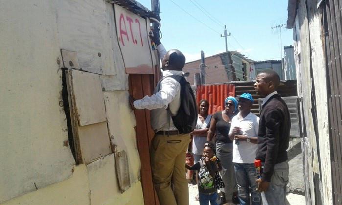
In the original pilot of Vukuzenzele with the AT Section community, a small prize pot (of a few thousand rand) was offered to the three teams voted as having the most suitable designs. The community decided to share this pot among all community members who had played the game.
Andy Bolnick had the following to say about incentives: ‘I think the prize money was an important enabler and attractor. I would suggest that in future endeavors there should be allowance made for prize money, especially if it is a re-blocking project of one settlement. In bigger projects linked with government (like a UISP) it might not be appropriate, but if it was clear that the game is facilitated by a non-government organisation then prize money should come into the mix. It really motivates people to attempt something they otherwise might have been nervous to try.’
Recommended steps
-
Onboarding of the targeted community: Select a group of players by working closely with the Project Steering Committee. Ideally these players will have some experience in working with development issues in the community, such as volunteer groups, street committees, project liaison roles and any other leadership characteristics. Selecting and training these players will become part of a capacity-building strategy and ideally these persons will continue to play a critical role in the project.
-
Gameplay: Play the game described above in an interactive way. Our skilled facilitators will be available to support the teams as they interact, solve the puzzles and ultimately contribute in a meaningful way to the planning of the project.
-
Debrief and close out: Following gameplay, it is advisable that the skilled facilitators set up a debriefing session with the players. Be sure to capture the inputs received here in audio recordings and transcribe the inputs for project reporting and ongoing refinement and improvements.
-
Game files processed: The gameplay files are processed and ReBlok writes a short recommendations report to the project team to indicate how to best incorporate the design. The town planner will be ultimately responsible for settlement layout to be approved by the client, provincial or local government.
Other helpful resources
Contact ReBlok at info@reblok.co.za for a demonstration of the game.
ReBlok services
Vukuzenzele is the flagship product of ReBlok and comes with skilled facilitators who can direct the outcomes of the gameplay.
Step 9: Prioritisation and design refinement
Description
Now that the gameplay has been concluded and the game file has been processed, recommendations for settlement planning will be submitted to the project team and professional town planners. The refinement of the design will hence incorporate community participation and recommendations should be considered and tested for their feasibility.
Important considerations
When commencing the formal layout planning with town planners, engineers, architects, surveyors, environmentalists, sociologists and other professionals, it is important to take the community along on the journey. In-situ upgrading is inherently more complex than a turn-key housing development, and implicates the everyday lives of residents.
It is important to show the community how their recommendations are being incorporated in the layout plan. This requires skillful negotiation and mediation to arrive at a position where all parties are satisfied with the outcome.
What you would need
- Vukuzenzele processed game file and recommendations report.
- Record of engagement with community.
- Close out report of the pre-planning phase.
Recommended steps
-
Facilitated handover of the game file to professional teams: The game file will be refined and will be included in a recommendations report summarising the gameplay experience and the debriefing with the community. The recommendations emerging from the gameplay file will be discussed with the project team and all efforts should be made to include as many possible and feasible aspirations communicated by the community.
-
ReBlok close out and handover: At this point in time, ReBlok exits the project cycle after completing the schedule of work it was appointed to carry out. The gameplay file has been incorporated in the draft concept and/or detailed layout plan, to be considered and signed off by the client (e.g. provincial or local government).
Other helpful resources
-
CSIR. 2000. Guidelines for Human Settlement Planning and Design (The Red Book, Vols 1 and 2): These guidelines have remained relevant over the past two decades, and the CSIR is currently working on a revised version. Until such time as the new version is published, the Red Book remains the definitive technical guide to human-settlements planning and design.
-
NUSP. 2018. NUSP Resources Kit: This 10-part training course available for free online has some of the best materials for training teams embarking on settlement upgrading, and it is highly recommended that these resources be studied by the PSC.
ReBlok services
ReBlok does not offer professional town-planning services, but will remain committed to the process until handover to the professional team.
Step 10: Implementing the design
Description
ReBlok does not become involved in implementation. However, iKhayalami offers a wide range of solutions for participatory settlement upgrade and development including re-blocking, sustainable-technologies and micro-finance-loan books. iKhayalami is also a co-founder of ReBlok and brings more than a decade of experience to bear in the project environment.
Important considerations
A large upgrading project could easily stretch over eight years as indicated by the project flow in Part A of this guidebook. During this time, there will be a lot of changes in the project team make up, the client’s representatives, community leaders and their structures, and so forth. It is important to keep the community engaged in this long-term process to avoid dissatisfaction and even direct protest action. It is therefore advisable to schedule the implementation plan so that there are at least deliverables every six months to a year.
Subject to funding, sections of the settlement might need to be ‘re-blocked’ to re-settle residents following relocations due to infrastructure development, ecologically sensitive areas, and so forth. If a re-blocking project is considered, iKhayalami could be a valuable service provider and partner in the project context.
Policy focus: The City of Cape Town adopted a ‘re-blocking’ by-law in 2013 after the body of evidence from experimental projects by iKhayalami and Community Organisation Resource Centre (CORC) proved the concept had relevance and applicability. Since that time, the council has allocated funding from the USDG to support re-blocking projects.
In Cape Town, re-blocking remains an option as one of many intervention strategies when upgrading an informal settlement.
What you would need
- Finalised layout plan.
- Project-management plan and allocated resources and budgets indicating short-, medium- and long-term projects.
- Functional Project Steering Committee.
- Strong communication protocols with the community.
- Relocation (and potentially reblocking) strategies where space needs clearing.
Recommended steps
-
Following the project plan: The involvement of the ReBlok team potentially comes to a close at the completion of Phase 1: Pre-Planning of the UISP project cycle. The activities that follow are predominantly those of service delivery, planning, engineering and associated in-situ upgrades. This work is guided by the project plan of the main contractor which in the past have mostly been engineering companies.
-
Sustaining community engagement: By taking a holistic view of the nature of the upgrading project, other services will be crowded into the project cycle. This requires localised interventions such as public health, local economic development, social services and so forth. Such a holistic approach to the upgrading of the settlement will potentially result in human and economic development to the benefit of all residents.